Showing posts with label China. Show all posts

Wall Of China

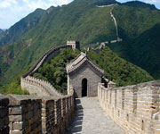
The Great Wall of China is a series of stone and earthen fortifications in northern China, built originally to protect the northern borders of the Chinese Empire against intrusions by various nomadic groups. Several walls havebeen built since the 5th century BC that are referred to collectively as the Great Wall, which has been rebuilt and maintained from the 5th century BC through the 16th century.

image
The Great Wall of China

One of the most famous is the wall built between 220–206 BC by the first Emperor of China, Qin Shi Huang. Little of that wall remains; the majority of the existing wall was built during the Ming Dynasty.

The Great Wall stretches from Shanhaiguan in the east, to Lop Nur in the west, along an arc that roughly delineates the southern edge of Inner Mongolia. The most comprehensive archaeological survey, using advanced technologies, has concluded that the entire Great Wall, with all of its branches, stretches for 8,851.8 km (5,500.3 mi). This is made up of 6,259.6 km (3,889.5 mi) sections of actual wall, 359.7 km (223.5 mi) of trenches and 2,232.5 km (1,387.2 mi) of natural defensive barriers such as hills and rivers.

image

image

image

image

image

image

image

image

More Images Here

You have read this article Asia / Asia Heritage / China / Heritage / Heritage China / Heritage Cultural / Mountains / Wonders / Wonders of Medieval World / Wonders of the Eight World / Wonders of the New World with the title China. You can bookmark this page URL http://tiffanyeatworld.blogspot.com/2012/03/wall-of-china.html. Thanks!

Karstic Peaks Guilin

Yangshuo is located in Yangshuo Town. Surrounded by karst peaks and bordered on one side by the Li River. It is easily accessible by bus or by boat from nearby Guilin. Over the years, it has become popular with foreign backpackers. Visitors to Yangshuo can swim in the Li River or the cleaner Yu Long (Dragon River), climb one of many nearby karst peaks, hire a bicycle for a cycling trip through the karst scenery, arrange a sightseeing trip on the Li River by bamboo raft or cruise boat, or visit a number of local cave systems, including a butterfly cave.

image
Karstic Peaks Guilin

Zhang Yimou's folk musical, "Impression Liu Sanjie", is a popular extravaganza performed outdoors in a river and mountain setting with a cast of 600 singers and dancers. Yangshuo is also China's foremost venue for rock climbing, with around 300 bolted routes and several companies offering guiding and equipment hire. Much of the town's traditional culture has been absorbed into the tourist industry, and tourists can pay a fee to watch fishermen fishing with cormorants, hire local women in traditional ethnic dress to pose for photographs, or take classes in Chinese calligraphy, tea ceremony, or cooking.

image

image

image

image

image

image

image

image

image

image

image

Text source:- Wikipedia. Images are copyrighted by their owners. Found any copyright issue, contact the administrator immediately. Report it now!
You have read this article Asia / China / Mountains / Peaks with the title China. You can bookmark this page URL http://tiffanyeatworld.blogspot.com/2012/03/karstic-peaks-guilin.html. Thanks!

Three Gorges Dam

The Three Gorges Dam is a hydroelectric dam that spans the Yangtze River by the town of Sandouping, located in the Yiling District of Yichang, in Hubei province, China. The Three Gorges Dam is the world's largest power station in terms of installed capacity (18,200 MW) but is second to Itaipu Dam with regards to the generation of electricity annually.

Three Gorges Dam

The dam body was completed in 2006. Except for a ship lift, the originally planned components of the project were completed on October 30, 2008, when the 26th turbine in the shore plant began commercial operation. Each turbine has a capacity of 700 MW. Six additional turbines in the underground power plant are not expected to become fully operational until mid-2011. Coupling the dam's thirty-two main turbines with two smaller generators (50 MW each) to power the plant itself, the total electric generating capacity of the dam will eventually reach 22,500 MW.

As well as producing electricity, the dam increases the Yangtze River's shipping capacity, and reduces the potential for floods downstream by providing flood storage space. The Chinese government regards the project as a historic engineering, social and economic success. With the design of state-of-the-art large turbines and a move toward limiting greenhouse gas emissions. However, the dam flooded archaeological and cultural sites and displaced some 1.3 million people, and is causing significant ecological changes, including an increased risk of landslides. The dam has been a controversial topic both in China and abroad.

A large dam across the Yangtze River was originally envisioned by Sun Yat-sen in The International Development of China, in 1919. He stated that a dam capable of generating 30 million horsepower (22,371 MW) was possible downstream of the Three Gorges. In 1932, the Nationalist government, led by Chiang Kai-shek, began preliminary work on plans in the Three Gorges. In 1939, Japanese military forces occupied Yichang and surveyed the area. A design, the Otani plan, was completed for the dam in anticipation of a Japanese victory over China. In 1944, the United States Bureau of Reclamation chief design engineer, John L. Savage, surveyed the area and drew up a dam proposal for the 'Yangtze River Project'. Some 54 Chinese engineers went to the U.S. for training. Some exploration, survey, economic study, and design work was done, but the government, in the midst of the Chinese Civil War, halted work in 1947.

After the 1949 Communist victory, Mao Zedong supported the project, but began the Gezhouba Dam project first, and economic problems including the Great Leap Forward and the Cultural Revolution slowed progress. After the 1954 Yangtze River Floods, in 1956, Mao Zedong authored "Swimming", a poem about his fascination with a dam on the Yangtze River. In 1958, after the Hundred Flowers Campaign, some engineers who spoke out against the project were imprisoned.

During the 1980s, the idea of a dam reemerged. The National People's Congress approved the dam in 1992: out of 2,633 delegates, 1,767 voted in favour, 177 voted against, 664 forfeited, and 25 members did not vote. Construction started on December 14, 1994. The dam was expected to be fully operational in 2009, but additional projects such as the underground power plant with six additional generators are expected to delay full operation until mid-2011. The ship lift is expected to be completed in 2014. The dam had raised the water level to 172.5 m (566 ft) above sea level by the end of 2008 and the maximum level of 175 m (574 ft) by October 2010.


Text source:- Wikipedia. Images are copyrighted by their owners. Found any copyright issue, contact the administrator immediately. Report it now!
You have read this article Asia / China / Dams / Wonders / Wonders of the Eight World with the title China. You can bookmark this page URL http://tiffanyeatworld.blogspot.com/2012/03/three-gorges-dam.html. Thanks!

China Danxia

China Danxia is the name given in China to landscapes developed on continental red terrigenous sedimentary beds influenced by endogenous forces (including uplift) and exogenous forces (including weathering and erosion). The inscribed site comprises six areas found in the sub-tropical zone of south-west China. They are characterized by spectacular red cliffs and a range of erosional landforms, including dramatic natural pillars, towers, ravines, valleys and waterfalls. These rugged landscapes have helped to conserve sub-tropical broad-leaved evergreen forests, and host many species of flora and fauna, about 400 of which are considered rare or threatened.

image
China Danxia
China Danxia is a serial property comprising six component parts (Chishui, Taining, Langshan, Danxiashan, Longhushan, and Jianglangshan) found in the sub-tropical zone of south-eastern China within approximately 1700 km crescent shaped arc from Guizhou Province in the west to Zhejiang Province in the east.

image

China Danxia is the name given in China to landscapes developed on continental red terrigenous sedimentary beds influenced by endogenous forces (including uplift) and exogenous forces (including weathering and erosion). It is characterised by spectacular red cliffs and a range of erosional landforms, including dramatic natural pillars, towers, ravines, valleys and waterfalls. The process of its development is characterised by a particular rock sequence, tectonic background, climatic conditions, erosional processes and landforms and these processes have been presented as an interim model.

image

Due to the combined endogenic (tectonic uplift) and exogenic (climatic, erosion, weathering) forces, and other factors, the Danxia landforms have been developed in red sedimentary sequences continuously from the Neogene until the present. The six component parts represent the most important examples of "least eroded" to "most eroded" Danxia landforms, providing a range of different aspects of the phenomenon, and illustrate both the range of landforms in relation to the forces and processes that formed them, together with a range of associated landscapes.

image

China Danxia is an impressive and unique landscape of great natural beauty. The reddish conglomerate and sandstone that form this landscape of exceptional natural beauty have been shaped into spectacular peaks, pillars, cliffs and imposing gorges. Together with the contrasting forests, winding rivers and majestic waterfalls, China Danxia presents a significant natural phenomenon.

image

China Danxia contains a wide variety of well developed red-beds landforms such as peaks, towers, mesas, cuestas, cliffs, valleys, caves and arches. Being shaped by both endogenous forces (including uplift) and exogenous forces (including weathering and erosion), China Danxia provides a range of different aspects of the phenomenon of physical landscape developed from continental (terrestrial) reddish conglomerate and sandstone in a warm, humid monsoon climate, illustrating both the range of landforms in relation to the forces and processes that formed them. The component parts represent the best examples of "least eroded" to "most eroded" Danxia landforms, displaying a clear landform sequence from "young" through "mature" to "old age", and with each component site displaying characteristic geomorphologic features of a given stage.

image

China Danxia satisfies the requirements of integrity. The property encompasses substantial elements of sufficient size to reflect the natural beauty and earth science values of Danxia landform from young stage through mature stage and to old stage. The boundaries of the China Danxia are adequate in relation to the nominated earth science and aesthetic values, and the buffer zone boundaries are also clearly defined. The level of management commitment appears adequate to the main challenges and threats that could face the property.

image

The property is state owned and its protected status varies between the six component parts: most have national park status, though land status also includes national nature reserve, national forest, and geopark. Each one of the six component parts is protected under relative laws and regulations at both national, provincial and local levels, which ensure the adequate long-term legislative, regulatory, institutional and traditional protection of the outstanding universal values.

image

Efficient management systems at different levels have been built with enough qualified staff in China Danxia areas. Planning for the serial property is advanced. An integrated management plan has been prepared for the property as a whole, as well as individual plans for the six areas in the series. These plans identify a clear rationale for management and mechanisms for the protection of the property. Research and adaptive management techniques, including baseline condition assessment and monitoring of change for both natural values and species have been established. Local communities are aware of the World Heritage nomination and all stakeholders are also very supportive of the World Heritage proposal, which ensures the long-term management.

image

image

image

image

image

image

Text source:- Wikipedia. Images are copyrighted by DKFLai, Hk Traveller, BadAssFlip, YONA PHOT, J Tongzs, Rick Lo, Teddy Wong and Alanalew. Found any copyright issue, contact the administrator immediately. Report it now!
You have read this article Asia / Asia Heritage / China / Heritage / Heritage China / Heritage Natural with the title China. You can bookmark this page URL http://tiffanyeatworld.blogspot.com/2012/01/china-danxia.html. Thanks!

Three Parallel Rivers of Yunnan Protected Areas

Consisting of eight geographical clusters of protected areas within the boundaries of the Three Parallel Rivers National Park, in the mountainous north-west of Yunnan Province, the 1.7 million hectare site features sections of the upper reaches of three of the great rivers of Asia: the Yangtze (Jinsha), Mekong and Salween run roughly parallel, north to south, through steep gorges which, in places, are 3,000 m deep and are bordered by glaciated peaks more than 6,000 m high. The site is an epicentre of Chinese biodiversity. It is also one of the richest temperate regions of the world in terms of biodiversity.

image
Three Parallel Rivers of Yunnan Protected Areas

Located in the mountainous north-west of Yunnan Province in China, the Three Parallel Rivers of Yunnan Protected Areas is a natural serial property consisting of 15 protected areas, grouped into eight clusters. The Property contains an outstanding diversity of landscapes, such as deep-incised river gorges, luxuriant forests, towering snow-clad mountains, glaciers, and alpine karst, reddish sandstone landforms (Danxia), lakes and meadows over vast vistas. The 1.7 million hectare site features sections of the upper reaches of three of the great rivers of Asia: the Yangtze (Jinsha), Mekong and Salween which run approximately parallel, north to south, through steep gorges which, in places, are 3,000 m deep and are bordered by glaciated peaks more than 6,000 m high. The property spans a large portion of the Hengduan Mountains, which is the major arc curving into Indochina from the eastern end of the Himalayas. Being located in the convergent regions of the three world's major biogeographic realms, the property is in an epicentre of Chinese biodiversity. It may also harbour the richest biodiversity among the temperate areas of the world.

The property is of outstanding value for displaying the geological history of the last 50 million years associated with the collision of the Indian Plate with the Eurasian Plate, the closure of the ancient Tethys Sea, and the uplifting of the Himalaya Range and the Tibetan Plateau. These were major geological events in the evolution of the land surface of Asia and they are on-going. The diverse rock types within the property record this history and, in addition, the range of karst, granite monolith, and Danxia sandstone landforms in the alpine zone include some of the best of their type in the mountains of the world.

The dramatic expression of ecological processes in the Three Parallel Rivers property has resulted from a mix of geological, climatic and topographical effects. First, the location of the area within an active orographic belt has resulted in a wide range of rock substrates from igneous (four types) through to various sedimentary types including limestones, sandstones and conglomerates. An exceptional range of topographical features - from gorges to karst to glaciated peaks -- is associated with the property being at a "collision point" of tectonic plates. Add the fact that the area was a Pleistocene refugium and is located at a biogeographical convergence zone (i.e. with temperate and tropical elements) and the physical foundations for evolution of its high biodiversity are all present. Along with the landscape diversity with a steep gradient of almost 6000m vertical, a monsoon climate affects most of the area and provides another favourable ecological stimulus that has allowed the full range of temperate Palearctic biomes to develop.

image

Northwest Yunnan is the area of richest biodiversity in China and may be the most biologically diverse temperate region on earth. The property encompasses most of the natural habitats in the Hengduan Mountains, one of the world's most important remaining areas for the conservation of the earth's biodiversity. The outstanding topographic and climatic diversity of the property, coupled with its location at the juncture of the East Asia, Southeast Asia, and Tibetan Plateau, biogeographical realms and its function as a N-S corridor for the movement of plants and animals (especially during the ice ages), marks it as a truly unique landscape, which still retains a high degree of natural character despite thousands of years of human habitation. As the last remaining stronghold for an extensive suite of rare and endangered plants and animals, the property is of Outstanding Universal Value.

The Three Parallel Rivers Property is composed of 15 different protected areas which have been grouped into eight clusters, each providing a representative sample of the full range of the biological and geological diversity of the Hengduan Mountains. Following boundary modifications accepted in 2010, the core areas cover an area of 960,084 ha, and each cluster is surrounded by a buffer zone covering a further 816,413 ha. The justification for inscribing a series of areas to represent this diversity is due to the fact that the area has been modified by human activities over thousands of years; note that in 2003 some 315,000 people lived inside the property, with 36,500 residing inside the core zone. However, much of the site is still relatively undisturbed and continues to perform its ecosystem functions. This is partially explained by the inaccessibility of the higher slopes and the relatively light impact of the subsistence activities of the resident populations.

image
Meili Snow Mountain Scenery

The boundary/area ratio for some of the components is extremely high, and connectivity between the component parts is also an issue. Some of the component parts are separated by precipitous river gorges, high mountain glacial divides and/or human settlement. Such a condition will result in a certain biological isolation, and options for linking the units via wildlife corridors would considerably help to enhance the integrity of the overall site.

image

image

image

image

image
Yangtze River

image

image

image
Tiger Leaping Gorge

image

image

Text source:- Wikipedia. Images are copyrighted by Loveexploring, International Rivers, Wai.Cheong and Hector Garcia. Found any copyright issue, contact the administrator immediately. Report it now!
You have read this article Asia / Asia Heritage / China / Heritage / Heritage China / Heritage Natural / Mountains / River with the title China. You can bookmark this page URL http://tiffanyeatworld.blogspot.com/2012/01/three-parallel-rivers-of-yunnan.html. Thanks!